|
last update 16/10/2009 |
|
Yakovlev
Fedor Home-page |
FOLDING formation research Guide: about the study of folded structures of several
scale levels into thin-layered flysch-like sediments in a Hinterland |
V. RESTORATION OF STRUCTURE FOR DOMAINS AND TECTONIC
ZONES, BALANCING SECTIONS
|
16. Reconstruction of sedimentary
cover structures for NW Caucasus in 3D models (ranks 3, 4, 5, 6) – since
2007. ·Description. Quasi-3D model of
sedimentary cover was constructed in three stages of North-West Caucasus
development. The structural materials of 11 cross-sections (by T.Giorgobiani and by Ye. Rogozhin,
Fig. 3, 4) were used as source of
information. The postulate of constancy of sedimentary cover volume was used
for calculations (Fig. 1). Cross-sections
were divided to 244 domains (and 42 structural cells, Fig. 2) and necessary geometrical parameters were measured. Prefolded states of domains were restored due to three
cinematic operations and shortening values of 42 cells were calculated (see Folder 13). The initial thicknesses of
sedimentary cover for each cell were measured in cross-sections or were taken
from literature. Combination of prefolded lengths
of tectonic cells (prefolded coordinates of cells
boundaries) and initial thicknesses of sedimentary cover (including the
bottom of Jurassic, Cretaceous and Paleogene
sediments) were used for the construction of first “pre-folded,
post-sedimentation” state of structure (Fig.
5). Because mountain building process took place sufficient later then
folding, two stages (“post-folded, pre-mountain-buildings” and
“post-mountain-buildings”) were constructed as separates ones (Fig. 6, 7). Shortening values of
cells (Fig. 8, 9) and its initial
thicknesses were used for calculation of new post-folded thicknesses and
depth of three sedimentary levels also as recent coordinates of cells
boundaries. Mountain building process gives the uplifting of structure and
magnitude of uplifting. Recent depth (high) positions of bottoms of Jurassic,
Cretaceous and Paleogene sediments were calculated
for each cell (Fig. 10, 11, 12). ·Publications. First
publication is the materials of Moscow Tectonic Meeting (Yakovlev F. “First
experience of 3-D model construction …”, 2007; PDF-R, N 22 in List-En), some refreshing in English is (Yakovlev F. “Common
principles of construction ...”, 2007; PDF, N
24 in List-En). Next is the materials of Moscow
Tectonic Meeting 2008 regarding the mountain building processes (Yakovlev F.L. “The study of
post-folding mountain building …” 2008; Abstract, in Russ. PDF-R, N29 in List-En), picture of distribution of uprising magnitude and
diagrams of parameters including. The last information is abstract, picture
of distribution of uprising magnitude including (Yakovlev, F. 2008 “The construction of pre-folding,
post-folding and recent stages of quasi-3D model …”,
SlovTec-08, PDF, N 31 in List-En). Full information exists in the presentation files *.ppt (SlovTec-08). (see download materials) Latest publications are (Yakovlev F.L. First version of
3D model of structure of North-West Caucasus sedimentary cover based on field
of fold related strain data… 2008. pp. 335- 345. [in Russian]
PDF-R); ·Materials.
There are files of posters in Russian and in English also as presentations
files. Let me
know about your interest by e-mail. *: yak@ifz.ru |
Fig. 1. The postulate of sedimentary
cover volume constancy during the folding
Fig. 2. The structural cells as
minimal structures which may be used for measurement of tectonic related horizontal
shortening (section 3 lays in boundaries of cell). Other lines are showing
different shortening values due to mesobuckling
related disharmony of strain. a – initial stage of two cells; b – structure after
mesobuckling perturbations. |
|||
|
|
||||
|
Fig. 3. The geological
map of North-West Caucasus and section lines |
Fig. 4. The detail structural
section as example of material. Section number 8 in two parts. |
|||
|
Fig. 5. The initial stage (1, postsedimental, prefolded) for
section 8. Data of 5 structural cells were calculated. Fig. 6. (to center) The stage 2 (postfolded, pre mauntain
building) for section 8. Cells were transformed by shortening of certain
values. Fig. 7. (to right) The stage 3 (post mountain
building, recent). Narrow columns show parts of sedimentary cover which were
eroded. |
|
|
||
|
|
|
|||
|
Fig. 8. The map of
structural cells transformations. Stage 1, postsedimental,
prefolded. |
Fig. 9. The map of
structural cells transformations. Stage 2 and 3, postfolded
and recent |
|||
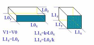
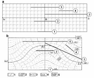
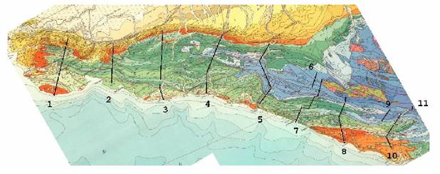
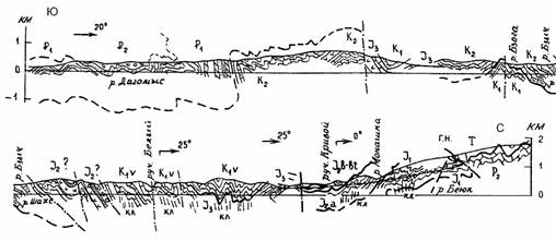
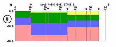
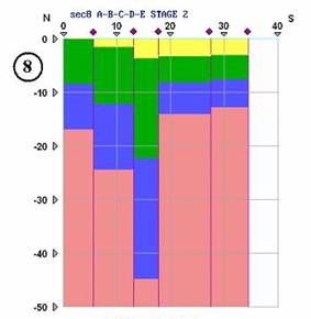
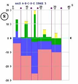
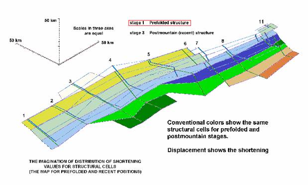
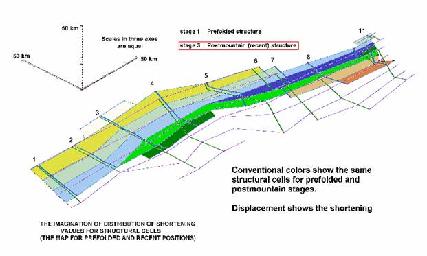
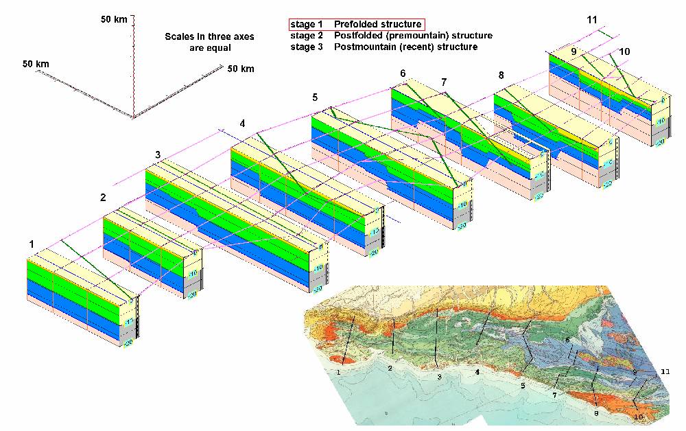
Fig. 10. The
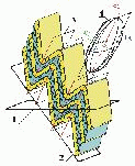
quasi-3D model of North-West Caucasus sedimentary cover structure. Stage 1, postsedimental, prefolded.
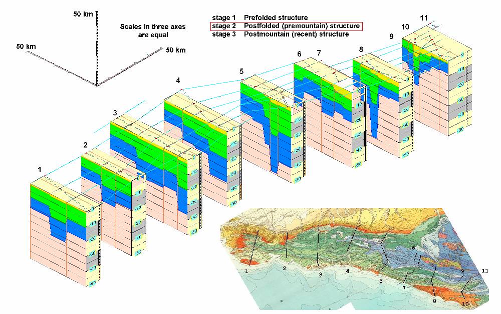
Fig. 11. The
quasi-3D model of North-West Caucasus sedimentary cover structure. Stage
2, postfolded, premountain
building.
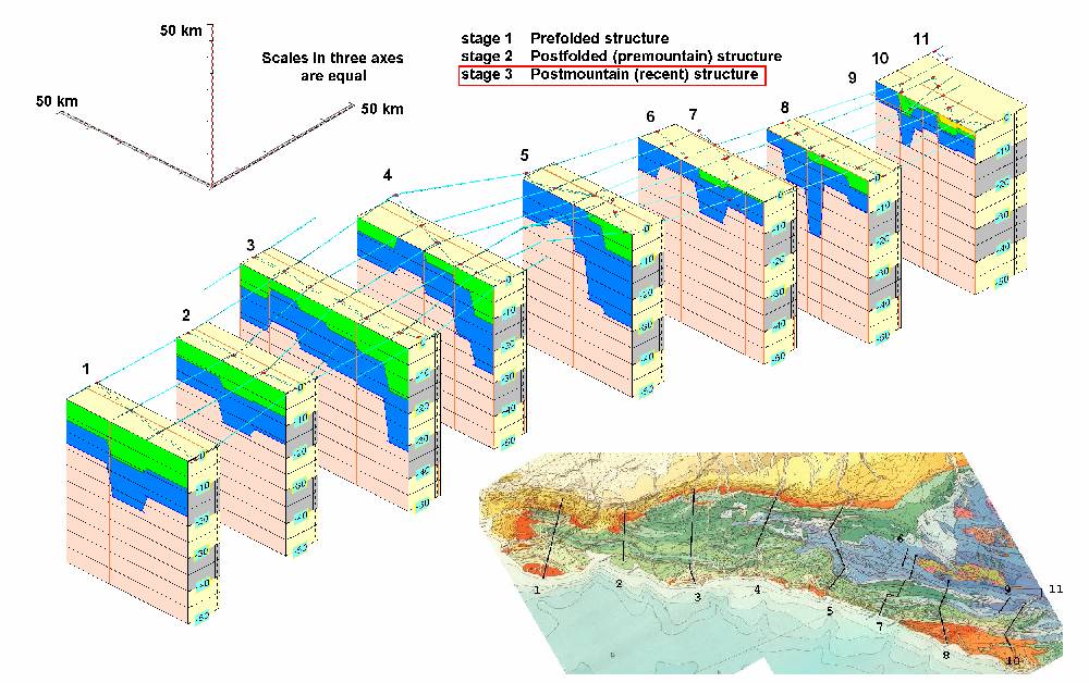
Fig. 12. The
quasi-3D model of North-West Caucasus sedimentary cover structure. Stage
3, postmountain building. recent.
|
© 2009, ИФЗ РАН, Яковлев |